BECOME A BETTER MAP RESEARCHER
Mapping
our ancestors' lives
Improve your family history search skills with the Family Tree Academy. This issue, David Annal pores over a range of historic map collections that are extremely useful for researching and visualising localities in the past
David Annal
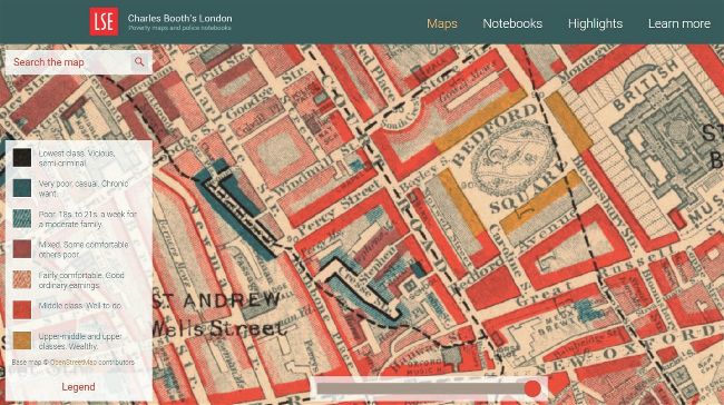
Explore the streets of late 19th Century London with Charles Booth’s maps: https://booth.lse. ac.uk/map. Note the legend, left, denoting the socio-economic status of the occupants of each street, as defined by Booth
ESSENTIAL SEARCH SKILLS TO MASTER
The Family Tree Academy is here to help you grow your genealogy skills. The aim is to help teach more about the search skills and source know-how needed to step up your family history related research.
In this issue, Family Tree Academy tutor David Annal looks at a range of historic map collections to help you trace the places in which people once lived and worked in centuries past.
A guide to the records
The documents that we use to research our family histories can only tell us so much about our ancestors’ lives. They provide us with the basic facts – the whos, the wheres and the whens – but if we want to gain a greater understanding of them as individuals, we need to spread the net a bit wider. We need to find answers to the hows and the whys.
Put their lives in context
When we focus on a particular family, it’s all-too easy to lose sight of the bigger picture. Whether our ancestors lived in a remote settlement in rural Wales, a small market town in the south of England or a rapidly expanding mill town in the industrial northwest, they were part of a community. Their friends, neighbours and workmates, as well as their more distant relatives, formed what we might today call their ‘social network’; these are the people we find living next door to them in the census returns, acting as witnesses at their weddings and signing their names at foot of their wills.
To my mind, there’s nothing better than a good map to help us set our ancestors’ lives in the context of their local communities. And whether their lives were rural or urban, the same social networks were in place.
Plotting places on a map
Birth, marriage and death certificates, census returns, parish registers and all the other traditional family history sources, are so full of useful genealogical data that we can sometimes overlook the details they provide about our ancestors’ homes. And even if we do pay attention to their addresses, it’s not until we start to use maps to locate them that we can start to make sense of it all. The simple process of plotting the addresses of their residences on a contemporary map will reveal that the majority of our ancestors didn’t move too far from where they were born.