Cover Feature
HACK YOUR MAPS!
Improve your navigation by exploring the best new and secret tools in mapping websites and apps. Robert Irvine reveals 20 free ways to make maps work better for you
Online maps have improved our lives far more than any streaming service or social network. No more struggling with unwieldy road maps, thumbing through street guides and stopping strangers to ask for directions. Now we can simply type our destination and receive instant information on how to get there, how long it will take and where we can grab a coffee on the way.
Google Maps, which celebrated its 20th birthday in February, is undoubtedly the most popular online mapping service, but – as you’ll know if you remember Multimap or Streetmap – it wasn’t the first, and it certainly isn’t perfect. However, it has spurred the development of alternative navigation tools that offer greater privacy, better designs and smarter features. Google even bought one of them, Waze, in 2013.
WHAT YOU CAN DO
• Plan routes that save you money on petrol or diesel
• Find your way around using augmented reality
• Improve the accuracy of maps that cover your local area
• Turn your phone into a car dashcam
• Enhance map information using layers
• Use a digital compass to help you find your way
• Plan walking and cycling trips around the UK
• Download country maps so you can navigate while offline
With so many mapping services to choose from, it’s easy to miss some of their most useful options, either because they’re new, tucked away or only available in tools you’ve never tried (or even heard of). In this feature, we reveal our favourite new hacks for online maps to make them work better for you.
We’ve explored dozens of mapping websites and apps – from the biggest names to lesser-known navigation tools – to bring you the best free ways to enhance your journeys, whether you’re travelling by car, bike, public transport or on foot.
MAPPING TOOLS THAT SAVE YOU MONEY
Choose the most fuel-efficient routes
Google Maps now helps you save money on petrol and diesel – or electricity if you drive an electric vehicle – by recommending the most fuel-efficient route. When you search for driving directions in the Maps app, it will automatically suggest the most cost-effective route and highlight it using a leaf symbol. This is based on factors such as the number of hills, condition of the roads and predicted traffic.
To activate the feature, tap your profile picture and choose Settings, then Navigation. In the ‘Route options’ section, switch on the option ‘Prefer fuel-efficient routes’ (see screenshot above right). To get more accurate advice for your engine type, select ‘My vehicles’ in Settings and choose from Petrol, Diesel, Hybrid and Electric. Although you won’t save much on shorter journeys, on longer trips it should mean fewer stops at petrol pumps or charging points.
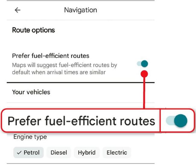
Save money on petrol by prioritising fuel-efficient routes
Calculate petrol costs in advance
Find out how much a car journey will cost by installing the browser extension Google Maps Fuel Cost Calculator(www. snipca.com/53897, Chromium browsers). Enter your vehicle’s fuel efficiency in miles per gallon ( 1 in our screenshot below) or kilometres per litre, and the current price of petrol or diesel, then click Save. When you search for driving directions on the Google Maps site, you’ll now see estimated fuel costs for different routes so you can choose the cheapest 2 .
The RAC offers a similar ‘Mileage calculator’ feature on its Route Planner website(www.snipca.com/53898). Enter the details of your journey, engine type and fuel consumption to view the cost for different sizes of vehicle.
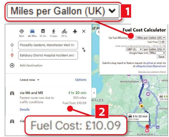
Estimate your petrol costs using Google Maps Fuel Cost Calculator
Compare fares on public transport
The excellent transport app and mapping service Citymapper(www.snipca. com/53894) now lets you compare the fares for public-transport routes around dozens of major UK and European cities. These include London, Birmingham, Lincoln, Liverpool, Edinburgh and Glasgow.
Enter your start and end points ( 1 in our screenshot below), and Citymapper will calculate the cost of your trip via different bus and rail methods 2 . The new feature works on the Citymapper website, and in its apps for Android (www.snipca. com/53895) and iOS (www.snipca. com/53896), and also tells you when and where to catch the bus duration of your journey.